 alt Hacker News
Inception-style curved map for turn-by-turn directions
Comments
This is a really good proof of concept. I would use this.
Something about the moment of the turn itself isn’t working for me though. Just before the turn you have essentially no information about the route ahead, until after the turn is completed. This would make a sequence of consecutive turns difficult to navigate.
This looks pretty neat but also distracting and not very convenient. A useful follow mode should provide a view into the next several dozen seconds of road conditions. This projection forces road sections after sharp turns to go off screen, and does nothing to compensate for that (e.g. by rotating the view), so the distance and time of useful prediction changes constantly. Since you're already willing to give the driver nausea, consider unwrapping 90 degree turns into something more straight until they're close enough.
I see a whole new business category being born: Nausea as a Service!
This is surprisingly useful. As I was imagining myself behind thr wheel I felt it was more clear as to when/where the next turn is. Probably because it combines top down flat with 3d spatial vs just one or the other. This was really good. I want it.
Great idea and demo. My main gripe when using Google Maps in the car is lack of information about the next turns — when do I change lanes, and to which one? This could be natively addressed here, especially if the blue navigation line was a little thinner and showed which lane(s) the driver needs to take.
This is cool. May I suggest that you make the standard deformation much less spherical? I do not get nauseous that easily and it made me a little nauseous, feeling like I was falling. I would not want to watch that while driving in a car. But 1/3 of the way from ‘flat’ to that would be super useful.
Neat!
It might be useful to be able to configure the map viewing angle at the top and bottom of the frame, perhaps even the degree of curvature between them.
I say this because I wonder if a shallower gradient (slightly more top-down at the bottom and slightly more angled at the top) would be more understandable and familiar while providing almost as much information. Not as cool-looking, but potentially more useful as a real navigation aid.
Patent Pending?
Any patent attorneys here know what exactly about this is "patent-able"?
That's almost perfect.
Proposal: The use case is to inform the user of landmarks on the route before they need them, giving visual cues about the scenery.
It's missing an early distortion along the direction of the turn though, each turn feels jarring and drops the useful spatial awareness aspect.
The concept is good, the implementation not so much, at least not on desktop. Mouselook doesn't make sense here; A and D should turn, not sidestep, which you can't do in a car. You do show a car right at the outset so people are going to imprint on that. Lack of arrow key support also alienates non-gamers.
Patent Pending, In europe?
TIL Software Patents are still totally a thing in Europe via a back door.
Thanks for sharing! Building this in public, check my X for more updates! https://x.com/karshuit
A problem of open GeoData is very much their coverage and availability in the EU. While the countries and their survey offices are required to release high value datasets in standardized form, some simply don’t. In Germany we have 16 states and every one of them has their own standard and pipelines for generating that data, and everyone releases it differently. Take LiDAR: Bavaria should be distributing it through OpenData portals and is required to by the EU, but they simply ignore that and charge 8000€ for it. Building international or even EU wide geo-projects from OpenData like https://hillsha.de is difficult because of that, you never get full coverage.
But as a tool for mapbuilders for small areas or planned tours i think this could be great
I've been playing video games for decades and this made me sick to my stomach almost immediately, but neat otherwise
The top down view of upcoming traffic complications ahead of a forward angled view of your surroundings seems incredibly practical to me.
I'm fortunate to not suffer motion sickness in general, but I showed this to my wife for 5 seconds and she was feeling motion sick.
Personally, I love it. It's fun, and I look forward to using it one day in lieu of exclusively top down or forward angled alone nav tools.
let's give drivers motion sickness isnt a good strategy, just my opinion.
Beautiful perspective if you need to take a left in 500 meters. Not so great if you have to take a left in 3 kilometers because that would just not be visible.
Now of course you could change the parameters so that the upper screen border is 3 kilometers. But normal standard perspective is even better, because it can show you up to infinity. The inherent concept here is that there is a cut-off at the top, and that there is always a lot of unnecessary stuff near you whizzing by to look at / dopamine kicks. So you would have to constantly look at the screen - instead of at the road.
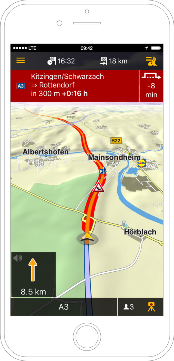
Navigon (among others) back in 2009 showed a perspective that balanced between showing the next junction and the next few kilometers. And leaving out anything unnecessary. I like that better. Example: https://www.notebookcheck.com/fileadmin/_processed_/csm_Garm...
I almost immediately click-dragged into a nearby building by accident, and am fascinated by how this engine attempts to extrapolate the inside of the building using only information about the outside. It's kind of surreal, and slightly more convincing than it feels like it should be at times
I don't really know why, but the thought of my (elderly) mother using this made me laugh almost as hard as the El Risitas guy[1]. I adore it, and it also should never ever be used in any car GPS scenario. It's far too distracting, and puts far too much emphasis on the places you are not going.
I could see it being useful for a more exploratory style of map, however. Games like Pokemon Go come to mind as a place where this would be pretty cool.
A variant of this but taking place on an O'Neill Cylinder would be amazing. I've always been captivated by the idea of the horizon curving up in front of you.
Absolutely honest question: what is the advantage of this over a top view navigation with the orientation following the orientation of movement? Am I missing something?
Very cool, after watching a minute it grew on me and I can see why the perspective is useful.
My immediate thought is that this is what is would be like to drive in The Spindle in Neuromancer or any similar space environment that’s spinning for artificial gravity.
In the demo, the "Destination" and "Point of Interest" seem to be floating around randomly. I'd expect them to point out the things they're labeling, but their movement seems to bear little correlation to anything.
Very cool but wow that just triggered motion sickness I didn't even know I had
this looks pretty cool. since it curves the the 3d map, what would it look like when you are driving through downtown highrises? would the tops of the buildings clash into each other?
what about steep uphill/downhill sections ?
Nice work! This sort of reminds me of a game I saw demo'd on HN about a year ago, where you could walk and talk to the people and do some tasks- the difference being - in that game the world felt like a convex sphere and here it is concave.
That was surprisingly nice. I get to see the far distance on the map. Something has to be done about turns, though. They’re far too whirly for me. Good demo!
Very cool. This would actually save me from those terrible times when the navigation tells me to turn, but not which lane is best for the next turn after that. Now I could visualize it clearly.
That being said, it is a little dizzying to watch.
At first I thought this was a cool gimmick, but this seems like it would be really helpful. You get to see the angle of the curve from the driver's perspective and the overhead view at the same time!
Folded cities being primarily associated with Inception instead of ringworlds really shows you pr is everything.
Nice. I'm loving seeing the increase in usage of Gaussian Splats these days.
And it's getting so much easier to create them too.
looks cool.
But estimating distances is hard, as is estimating road size. You can only plan one straight line ahead, and there's no "glance how many blocks before I make a left turn". Now it's "scan and process the entire straight terrain section with eyes recognizing crossings to get the count" Alternatively, I'll have to task switch all the time to it to not miss on the turn. Some hybrid map visual overlay that makes reading it at a glance easier would go a long way here.
Looks ok but easy to get lost literally into the weeds of the vegetation.
I don't remember a map from the movie so I didn't know what to expect. Instantly I love this. I actually wish I could have this rather than street view in Google Maps.
Would love this for walking around nyc
This is great but also i want to vomit
gave me motion sickness in the turns, but i guess i should be looking at the real road
Spent 20 seconds on it.
Very cool idea. I was on board until the first turn, then I just felt seasick.
Does it come with barf bags, or at least a discount coupon?
This would look great on an iPad mini running as the vehicle display.
And likely in most EVs.
It's completely wild that they're trying to patent a visualization that already existed in multiple movies.
Bad ass. Nicely done.
Finally something new and shiny. Looks promising.
Cute. Only runs at about 1fps on my 5yo LG phone but it's a miracle it runs at all.
First time I saw this idea was Berg's "Here and There" poster from 2009 (a year before Inception) though they acknowledge a bunch of earlier inspirations...
https://berglondon.com/blog/2009/05/04/here-there-influences...